From April 4-11 1947, a combination of melting snow, moderate-to-intense spring thunderstorms, and increased runoff resulted in downtown Flint’s Saginaw Street being submerged under chilly spring water, splitting downtown in half.
The amount of rain that fell in Flint was an average of 2.3 inches, and although this doesn’t seem like much to contribute to the flooding, the snowfall in March of 1947 made the soil frozen, which limited moisture infiltration in some areas, causing the increased runoff.
The Flint River rose so quickly over the Flint River Bridge, it was approximately 5.35 feet above the “flood stage,” which is what typically constitutes a river as being flooded.
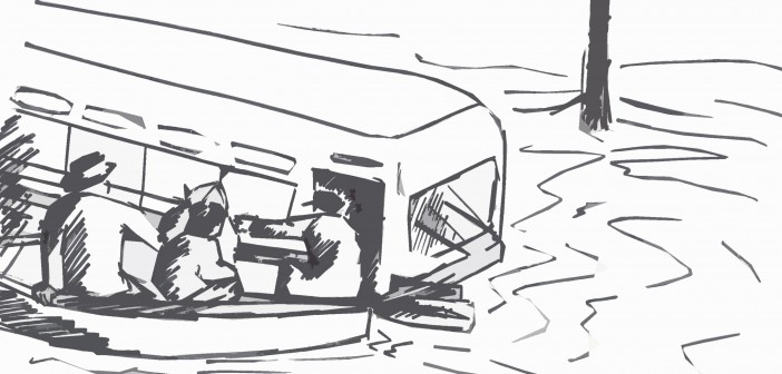
Most residents were left stranded, resorting to riding in small boats and makeshift rafts to stay afloat. The Kalamazoo, Grand, Saginaw, St. Clair, Clinton, River Rouge, and Flint river basins were the region’s most significantly impacted.
Residents watched refrigerators and washing machines float by, along with buses and other vehicles from which people had to be rescued. Many still attempted to go on with their daily routines; adults went to work and children played in the street. Unfortunately, it would take twice as long to get anywhere; some people couldn’t even make it to church services on Easter Sunday.
After most of the water was gone, many of the Downtown businesses eventually determined they would have to relocate because of interior and exterior damage to their buildings. This flood was the worst in the region since 1904.
Today, the angular Riverbank Park looks the way it does because of that infamous week in 1947. Built in 1979, Riverbank Parks also utilizes “landscape-as-infrastructure” to help with water runoff.
The Flood of 1947 is second in level of damage ($4 million) to the Beecher Tornado of 1953, which necessitated $10 million in repairs, including construction of the Holloway Reservoir, designed to prevent future water disasters.


